To get in touch with us please fill in this form and / or send us a message:

Our SwissHike tailor-made program includes three options which enable you to choose and optimise the content of your SwissHike Yoga Alliance activities. You may prefer more intensive Hiking tours and less Yoga & Meditation classes. Or you would like to enjoy more relaxation and contemplation sessions. You can set your own preferences in the schedule table. The final program and daily schedule will be tuned according to the composition of your SwissHike Clients Team.
The Swiss Mountains in Kandersteg is a beautiful area and ideal place for hiking in combination with a daily praxis of yoga, meditation and relaxation.
Our goal is to provide you with the ideal environment to gain new insights, access intuition, and rediscover your inner resources of happiness. Our daily combination of yoga postures, breathing exercises, deep relaxation, hiking, meditation and vegetarian meals have an optimal effect on body, mind and soul. It will increase your energy highly and extend your mind and consciousness in a way that all thoughts will disappear and in the end, you are there just in a silence of your Heart.

Yoga shows the path of harmony in duality, like diversity in unity.
Yoga healed my spine to a miraculous degree.
SwissHike and AlpenRetreat yoga teacher Jan Tomas
") You will have a smoothly guided yoga session in the middle of the Swiss Alps, twice a day.
You will have a smoothly guided yoga session in the middle of the Swiss Alps, twice a day.
You will learn the 5 points of Hatha Yoga with all basics of grounded integral hatha yoga techniques; the mindful breathing, different concentration methods, breathing exercise, full body relaxation, specific yoga diet, will be taught. And as well as the "effects & benefits" of yoga practice will be focused on this course. In the end, you will get a small file with documentation of remaining and improving your practice.
") A wonderful way to improve your yoga practice here in the Swiss mountains
A wonderful way to improve your yoga practice here in the Swiss mountains
Here you will get a full rounded Hatha Yoga session twice a day and with lots of creative ways of doing Integral Yoga. With many variations of postures and breathing techniques, basic mindful breathing in asanas and meditation, the integral practice of yoga and meditation in a natural environment of mountains, with delicious food and the company of other mindful practitioners, will harmonise and inspire your body, mind and spirit.
Simple living and high thinking, the power of thoughts.
") Intensive practical training of advanced hatha-yoga, to get further to your destination.
Intensive practical training of advanced hatha-yoga, to get further to your destination.
Advanced Hatha Yoga sessions, variations, long term asanas, and relaxation techniques, twice a day and 1-hour advanced Kundalini Yoga practice with specific breathing techniques, Mudras, Bandhas and Kriyas. An opportunity to connect to your intuition, awaken your life energy and enhance your personal aura.
The integral practice of yoga and meditation in a natural environment of mountains, with delicious food and the company of other mindful practitioners, can harmonise and inspire your body, mind and spirit. A stay in the mystic valleys of Kandersteg for spiritual sadhana can enhance your strength, joy and positive outlook on life. It can lead you to deeper inner self-knowledge.
We look forward to seeing you soon!

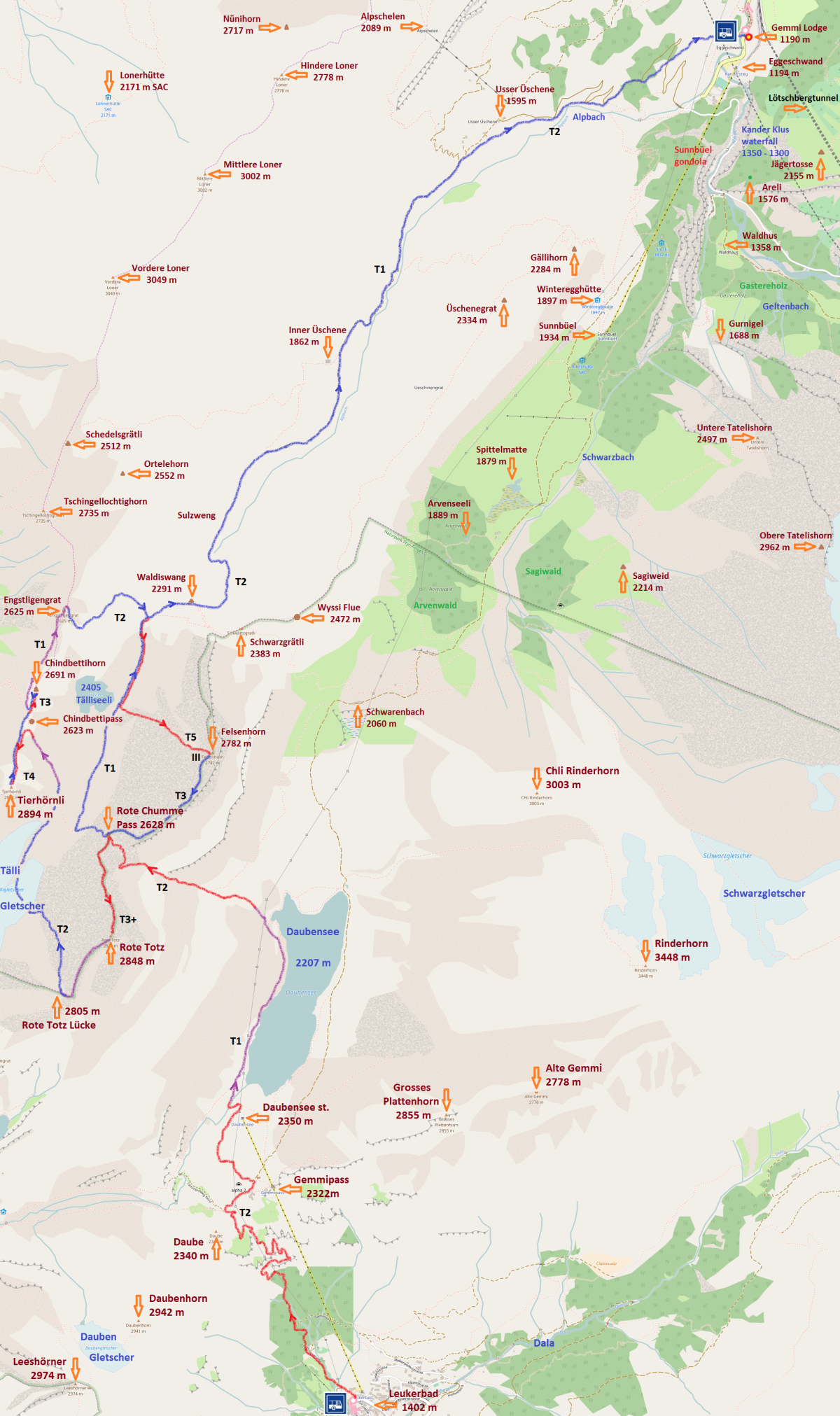
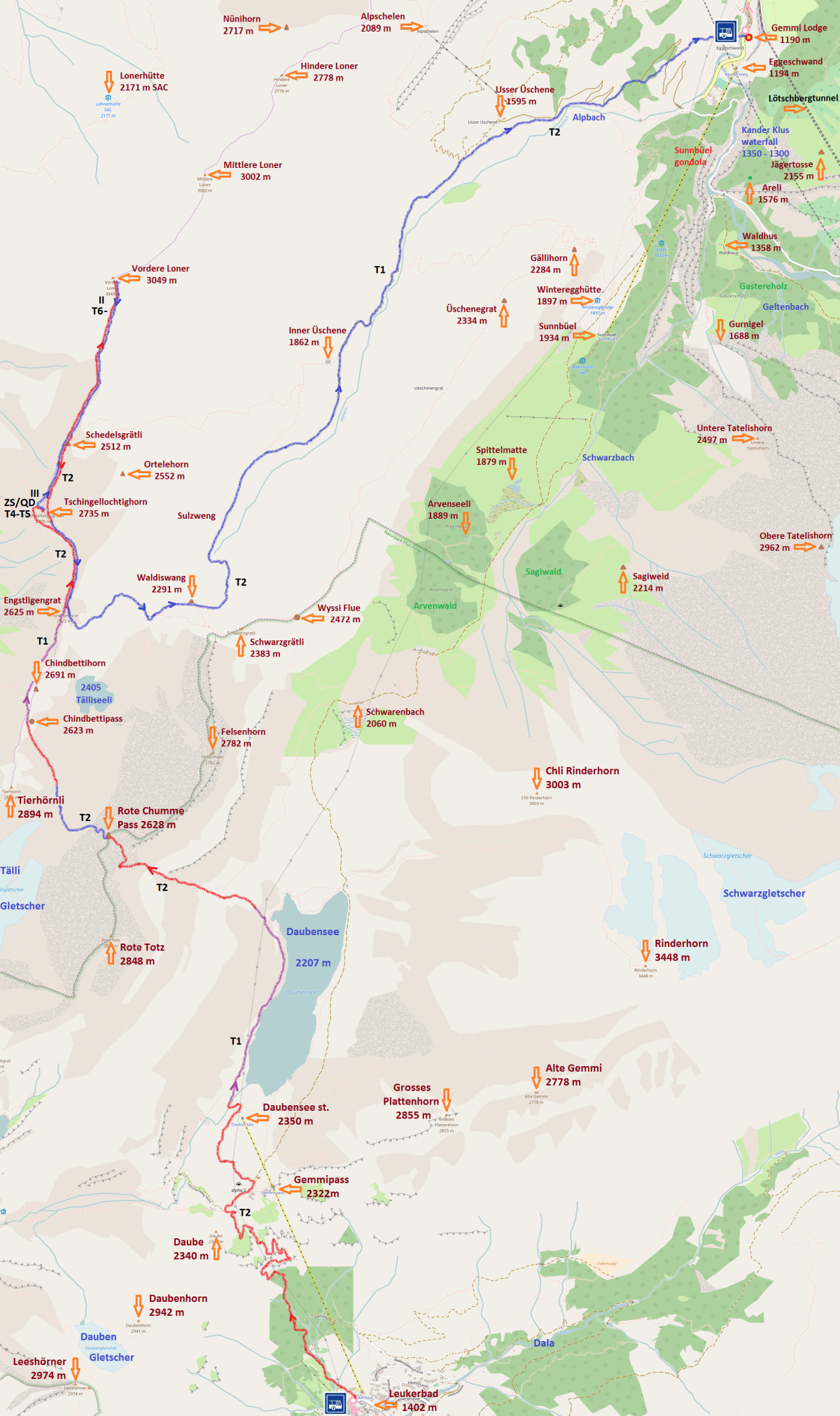
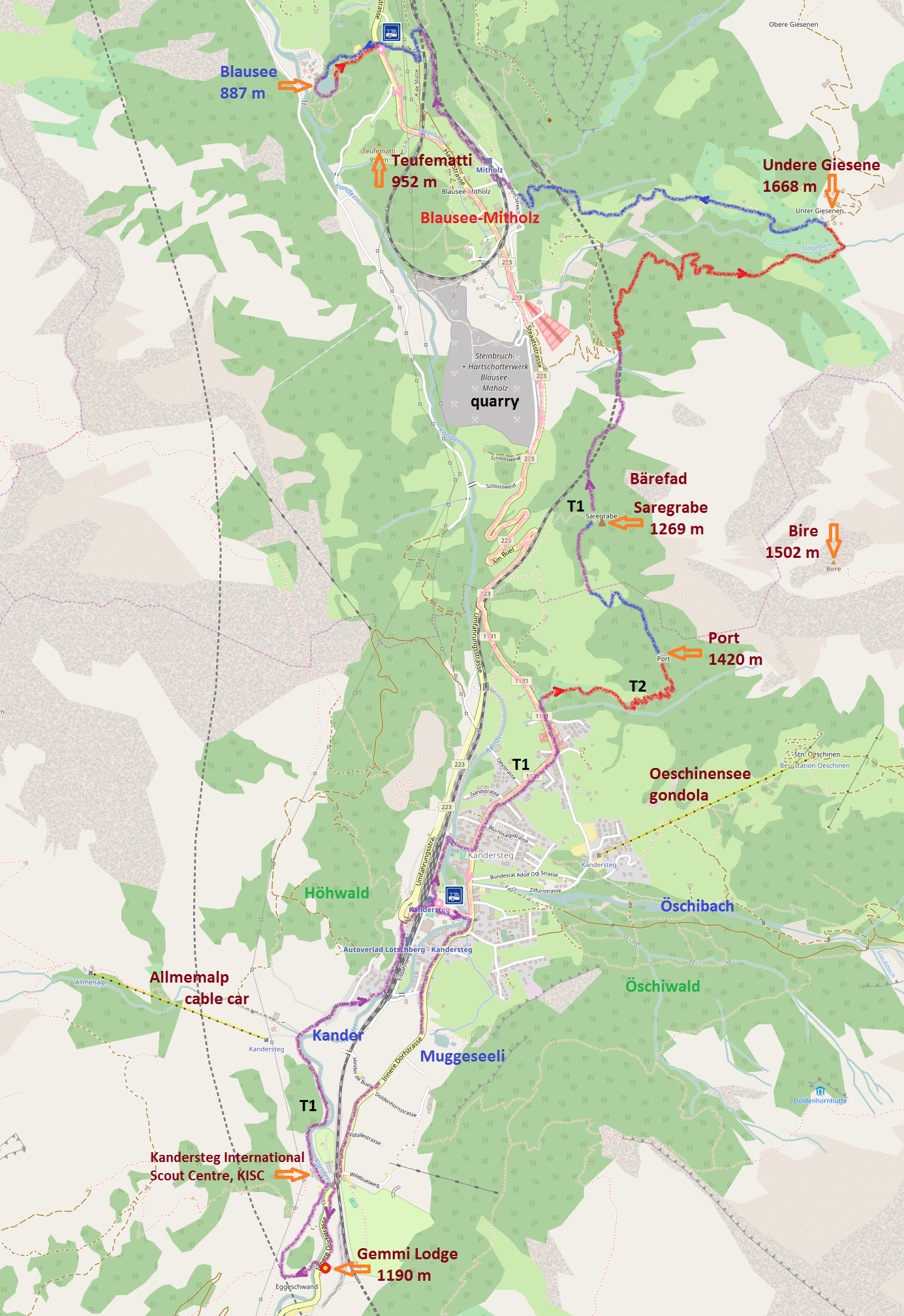
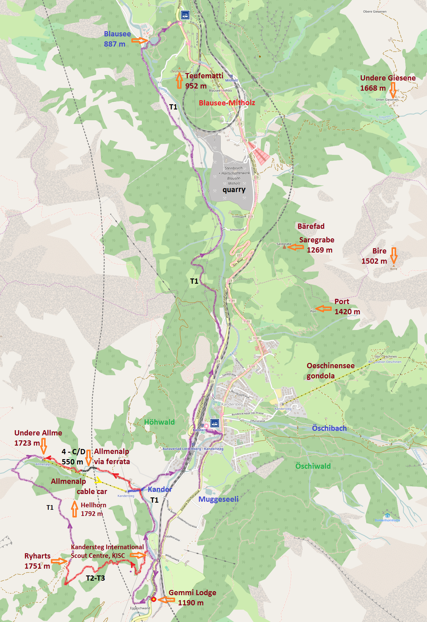
We are going to provide for SwissHike clients a detailed route description with a photo-documentation of all signposts and others orientation points.
Maps, compass, GPS and special mountaineering equipment will be accessible for each SwissHike group of levels L2-mountain and L3-summit.
Images for the SwissHike Photo Gallery will be taken on tours with digital cameras provided by our Project Partners and Active Supporters.
Although we'll support you with detailed tours descriptions, based on our knowledge, experience of SwissHike clients and the Internet research, eg. links on Welcome to HIKR - the Website for Hiking Reports, Join Flickr to explore world class photos, Schweizer Alpen-Club SAC, Kandersteg-Trails, Outdooractive - Hiking in Kandersteg, Kandersteg Tourismus, Wanderungen.ch-Arvenseeli, WeHike, you may prefer guided hiking with an assistance of the SwissHike local guides either on all your tours or only for some of them. Please choose one of the following options in the SwissHike booking form:
Self-guided tours - Alpine guide assistance only for summit tours of SwissHike level L3
Moderate support - SwissHike local guide assistance for only more difficult selected tours
Guided hiking - SwissHike local guide support for all hiking tours and selected walking routes

The basic 7-nights SwissHike Package you can reduce to 3 or 5 nights and extend to 10 or 14 nights, see the Package TYPE option
The basic 5-nights SwissHike Package you can reduce to 2 nights, see the Package TYPE option
| Day | Code - Valley Lev Var | Description - key points of the hiking route | Map |
|---|---|---|---|
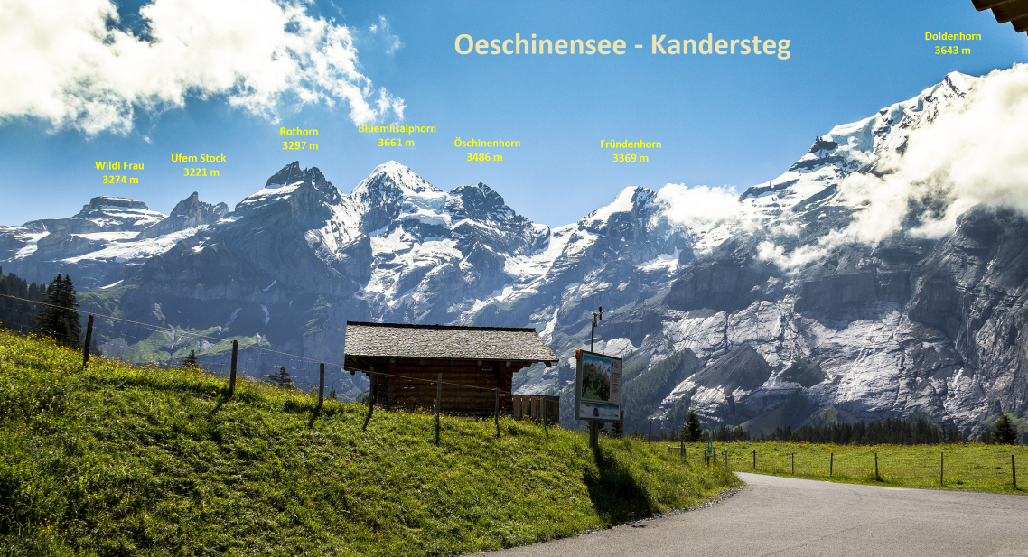
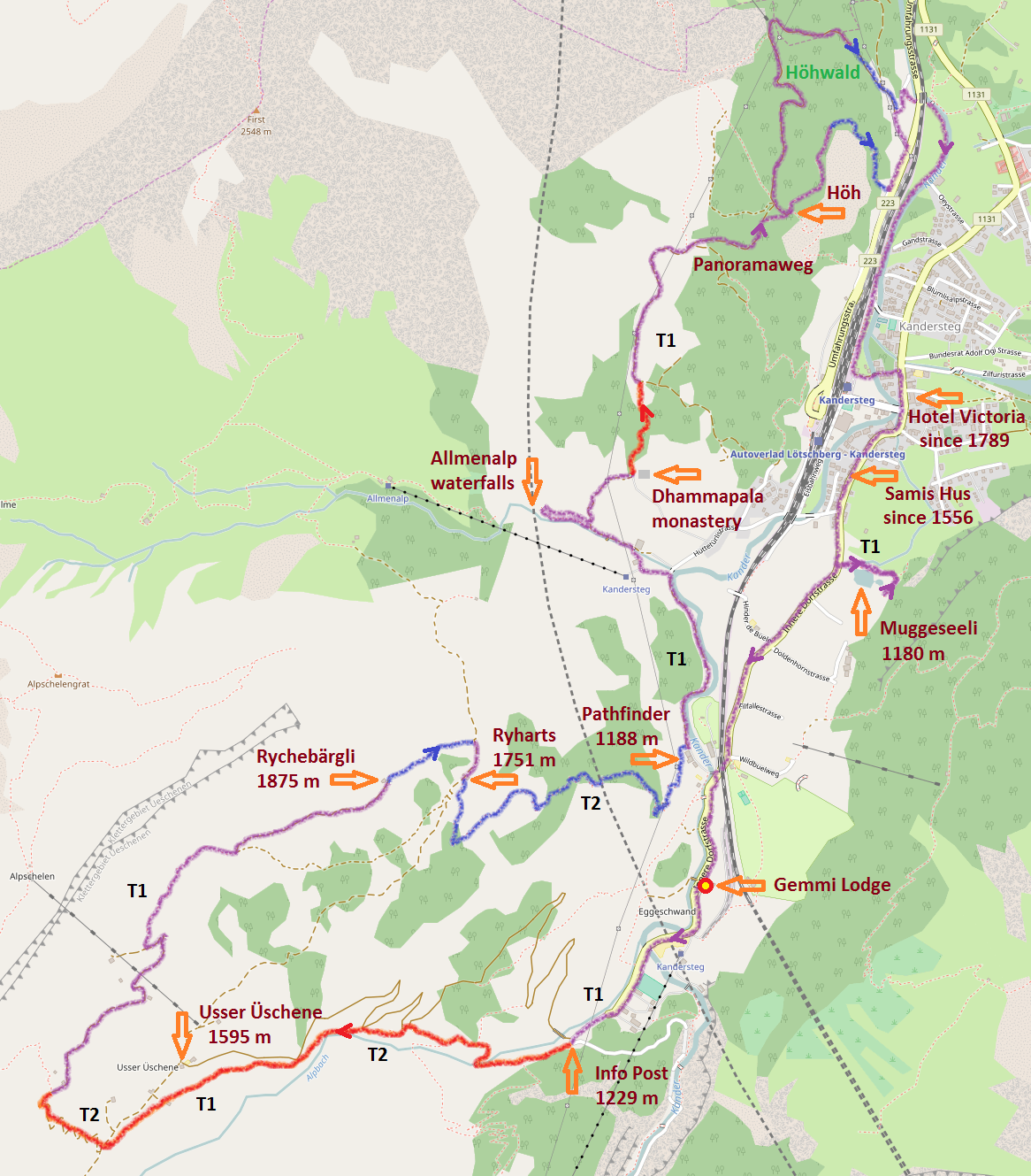
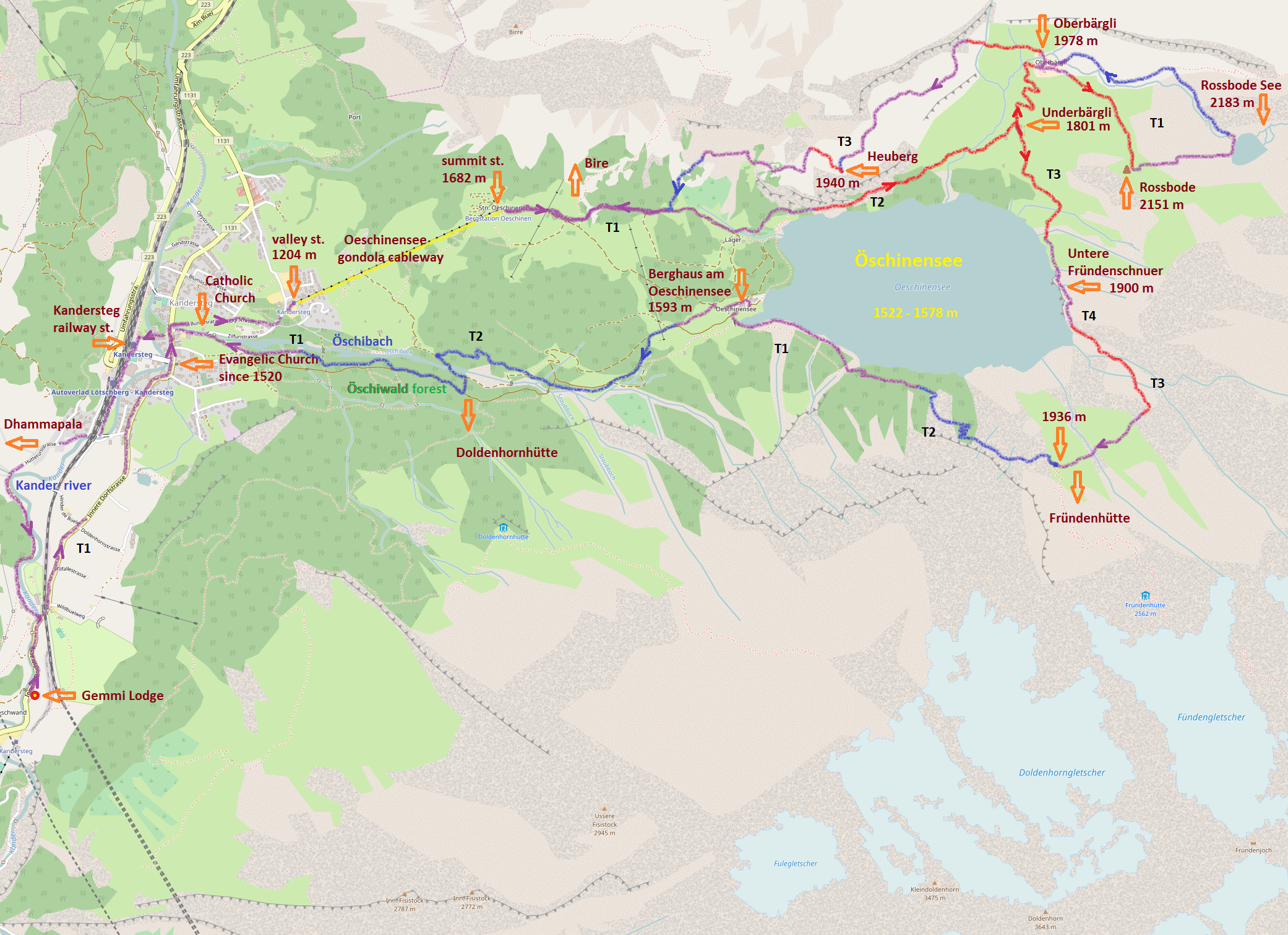
| 1 | Ks1 - Kandersteg L1 | Allmenalp waterfalls - Dhammapala monastery - Panoramaweg - Höh - Samis Hus - Muggeseeli | Ks1 |
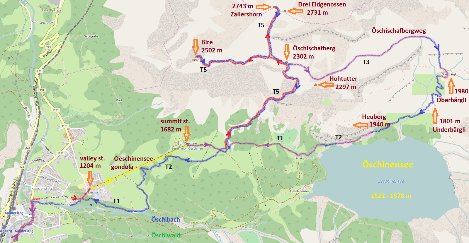
| 2 | Os1A - Öschinensee L1 vA | Öschinensee - Underbärgli - Untere Fründeschnuer - Berghaus - Öschiwald forest - Kander river | Os1A |
| 3 | Kt1 - Kiental L1 | Kiental - Fulbrunni - Tschingelsee - Griesalp - Oberi Bundalp - Reichenbach im Kandertal | Kt1 |
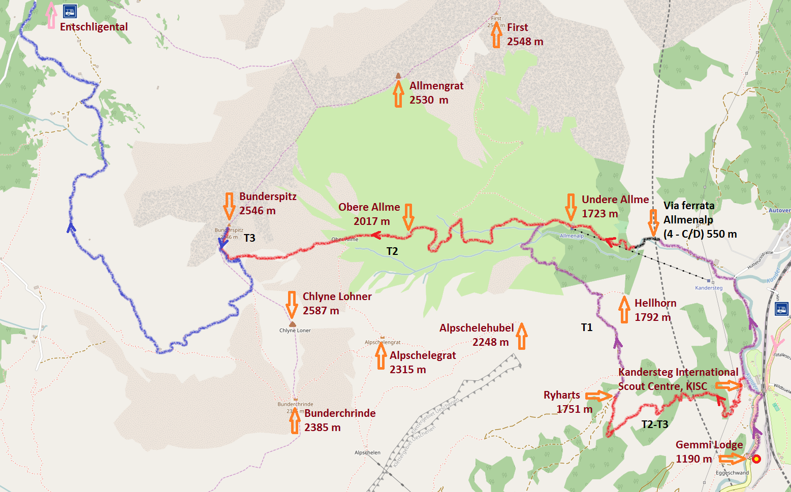
| 4 | Ap1A - Allmenalp L1 vA | Allmenalp cable car - Undere Allme - Obere Allme - Hellhorn - Ryharts - Usser Üschene | Ap1A |
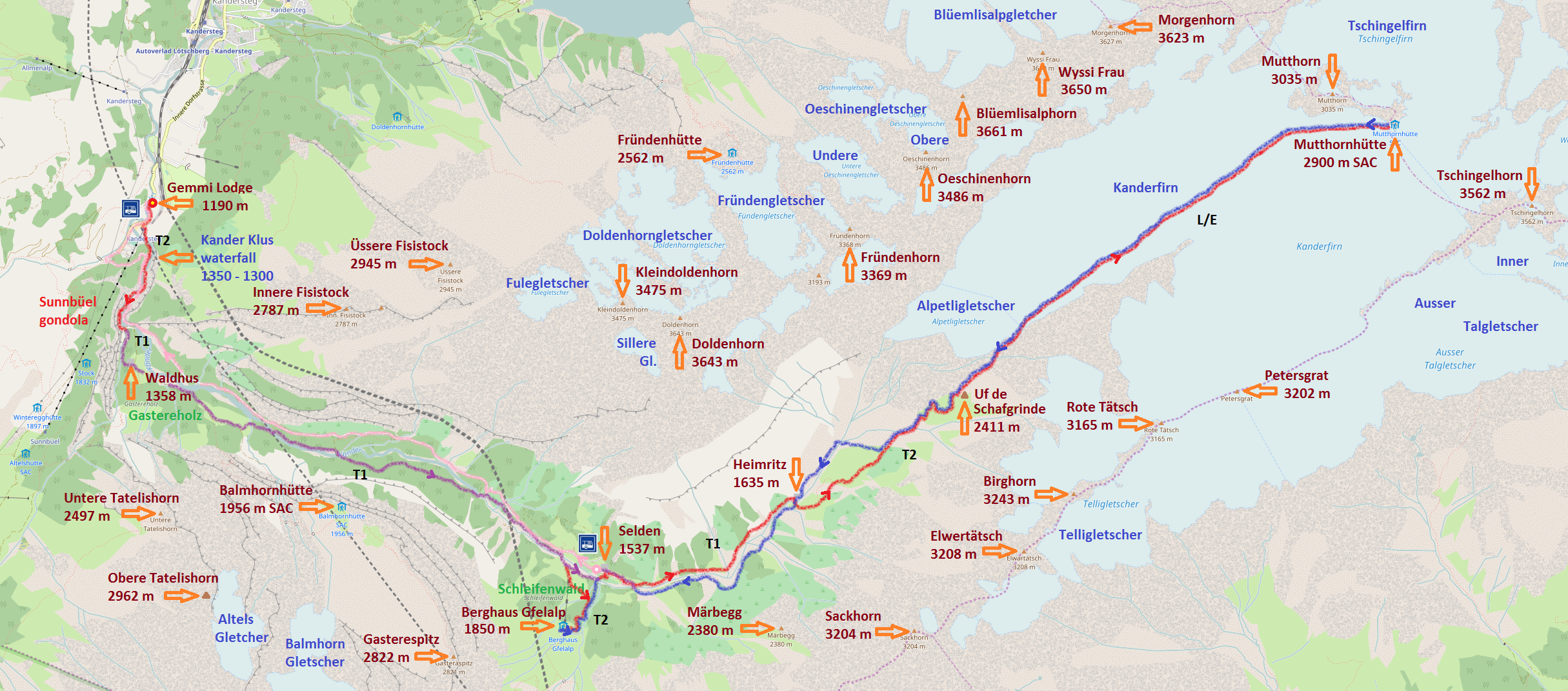
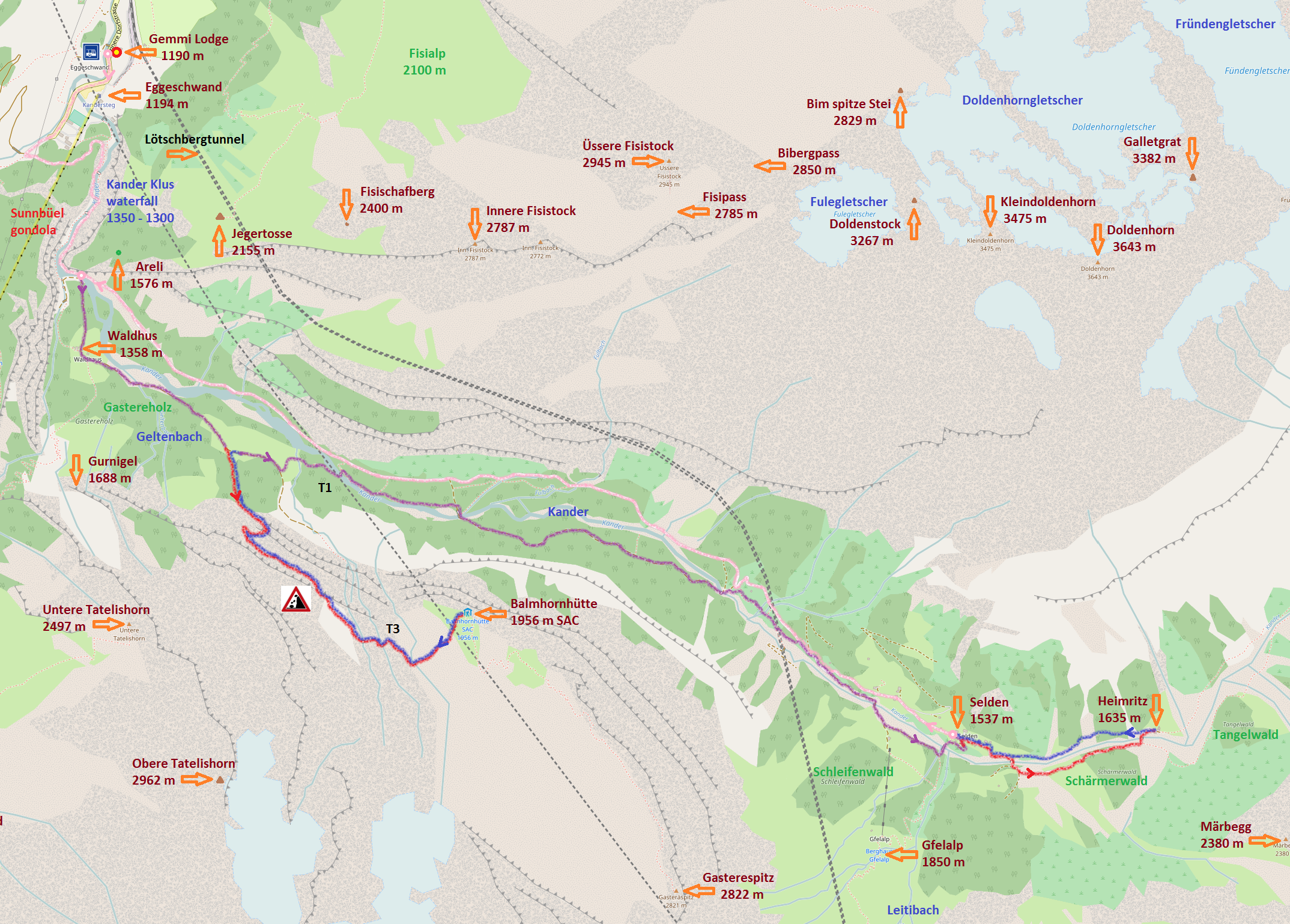
| 5 | Gt1A - Gasterntal L1 vA | Kander Klus - Gasterntal - Waldhus - /Gfellalp/ - Selden - Heimritz - /Kanderfirn/ - Selden bus | Gt1A |
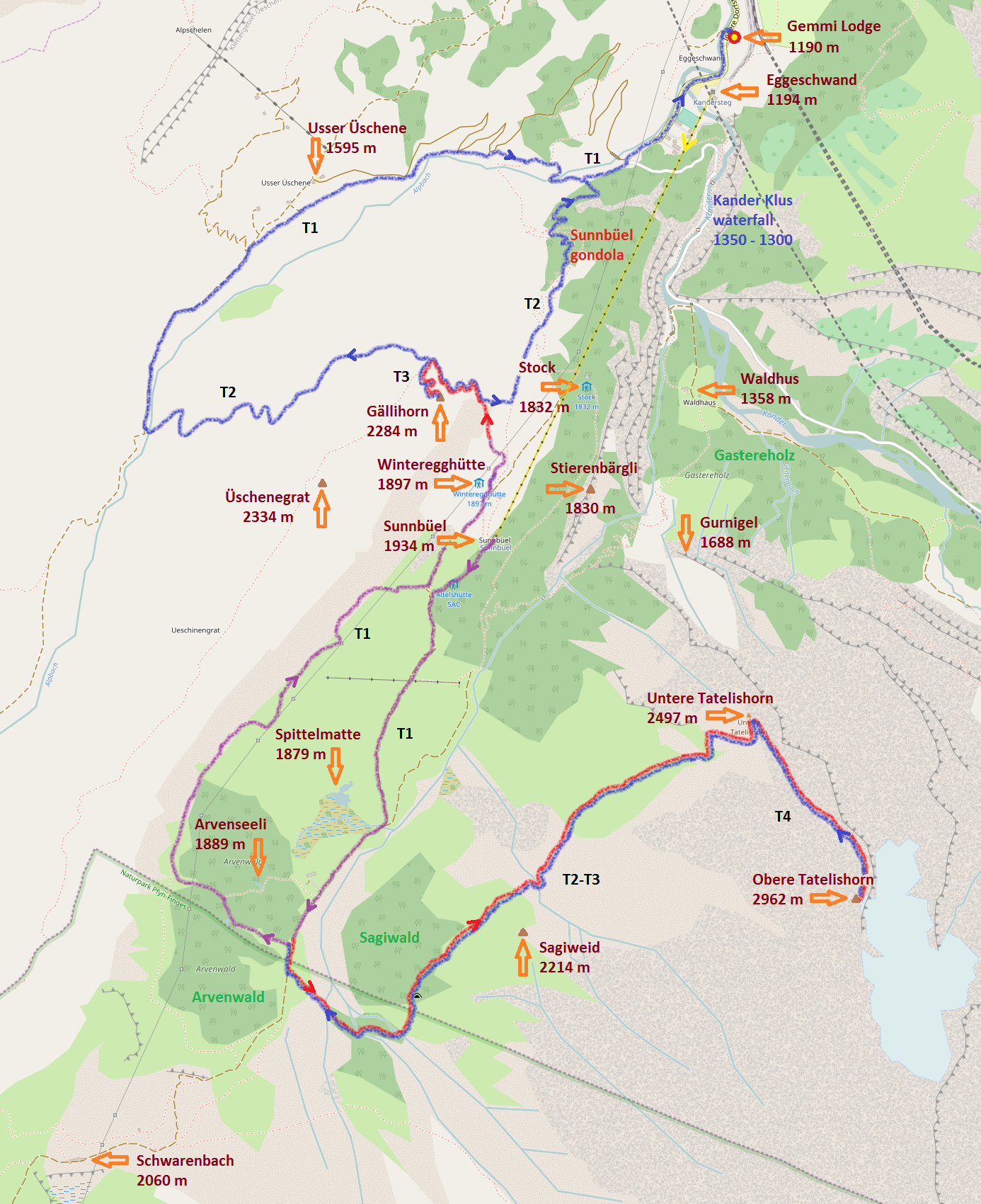
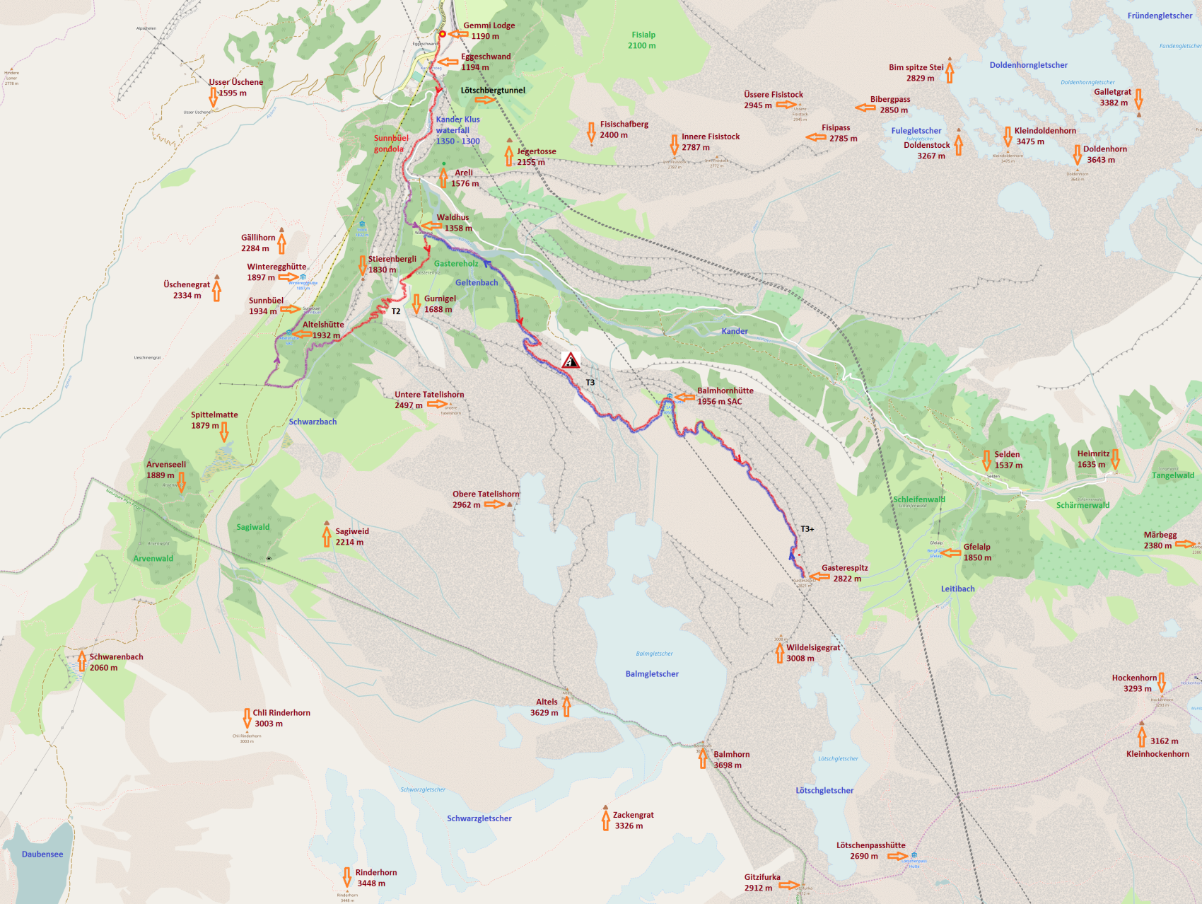
| 6 | Ge1A - Gemmi L1 vA | Sunnbüel - Stierenbergli - Stock - Winteregg - Spittelmatte - Schwarenbach - Arveseeli - Gurnigel - Waldhaus | Ge1A |
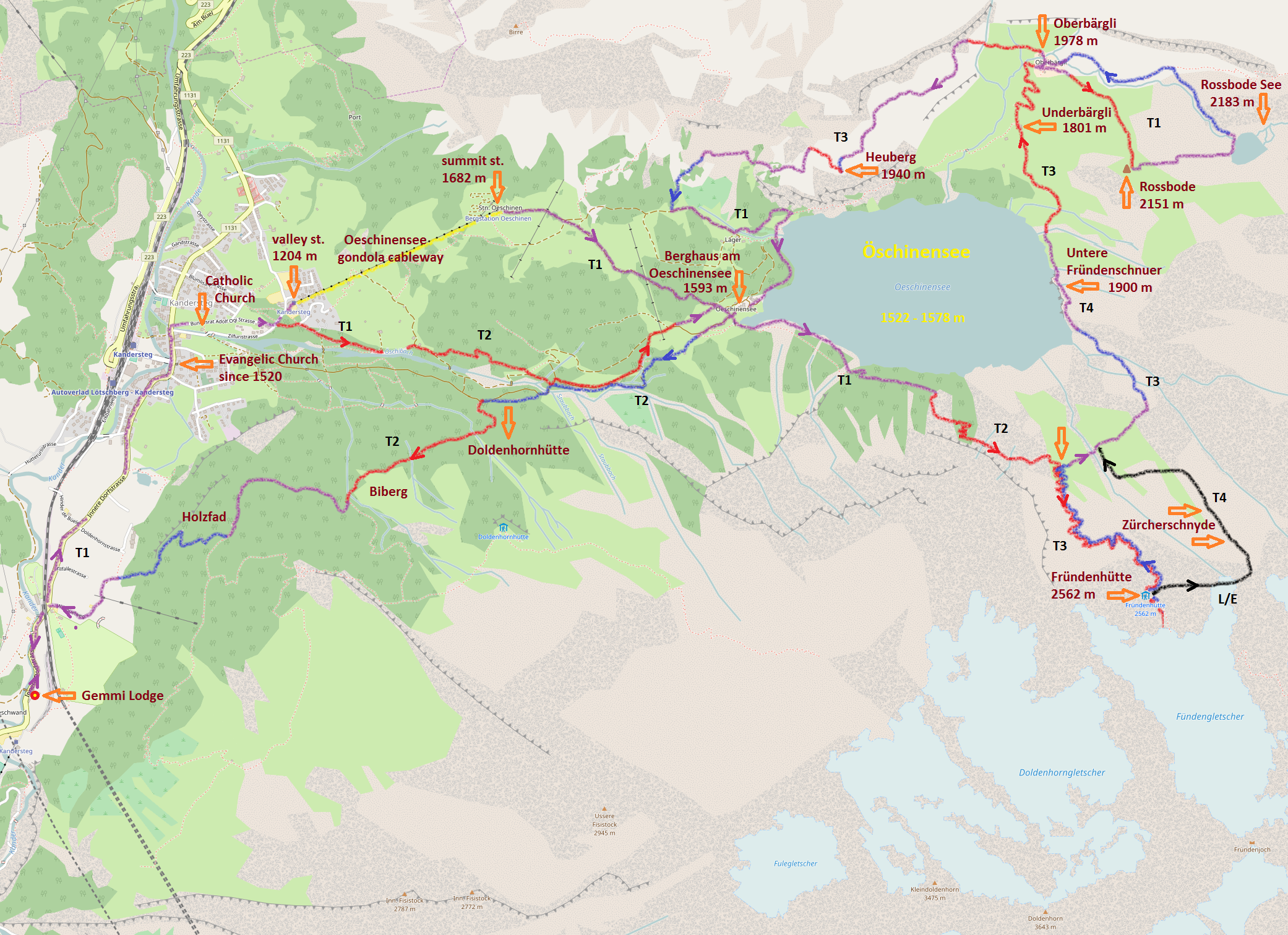
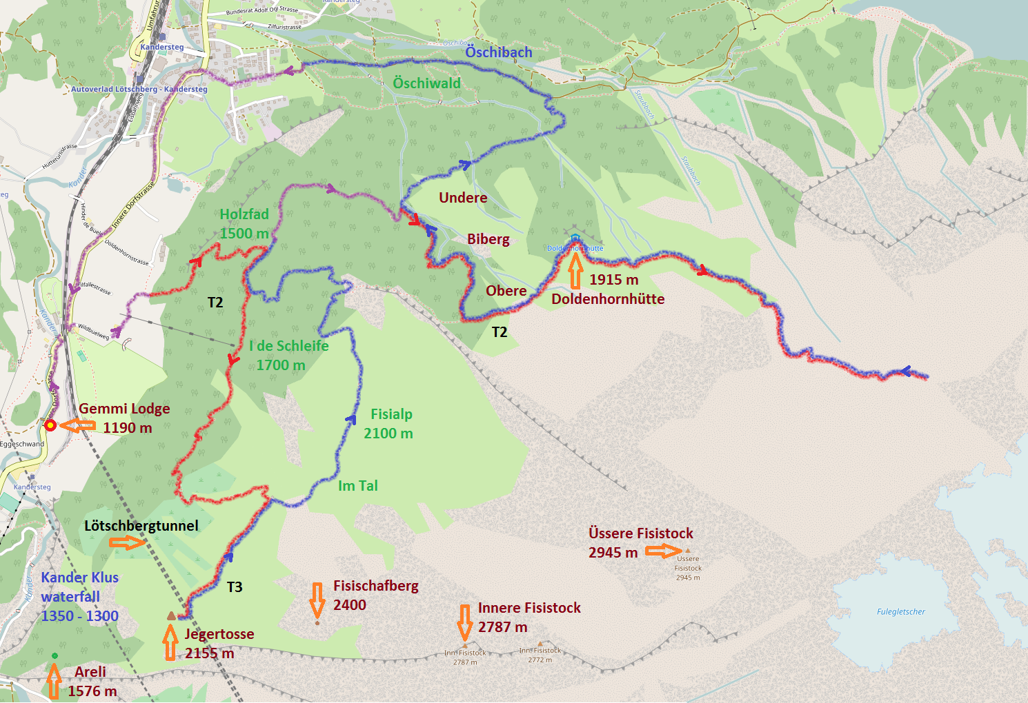
| 7 | Os1B - Öschinensee L1 vB | Holzfad - I de Schleife - Jägertosse - Fisialp - Biberg - /Doldenhornhütte/ - Öschiwald | Os1B |
| 8 | Ap1B - Allmenalp L1 vB | Sunnbüel - Gällihorn - Usser Üschene - Alpschelehubel - Obere Allme - Allmenalp | Ap1B |
| 9 | Gt1B - Gasterntal L1 vB | Bus Waldhus - Balmhornhütte - /Heimritz/ - Selden - Bus Eggeschwand | Gt1B |
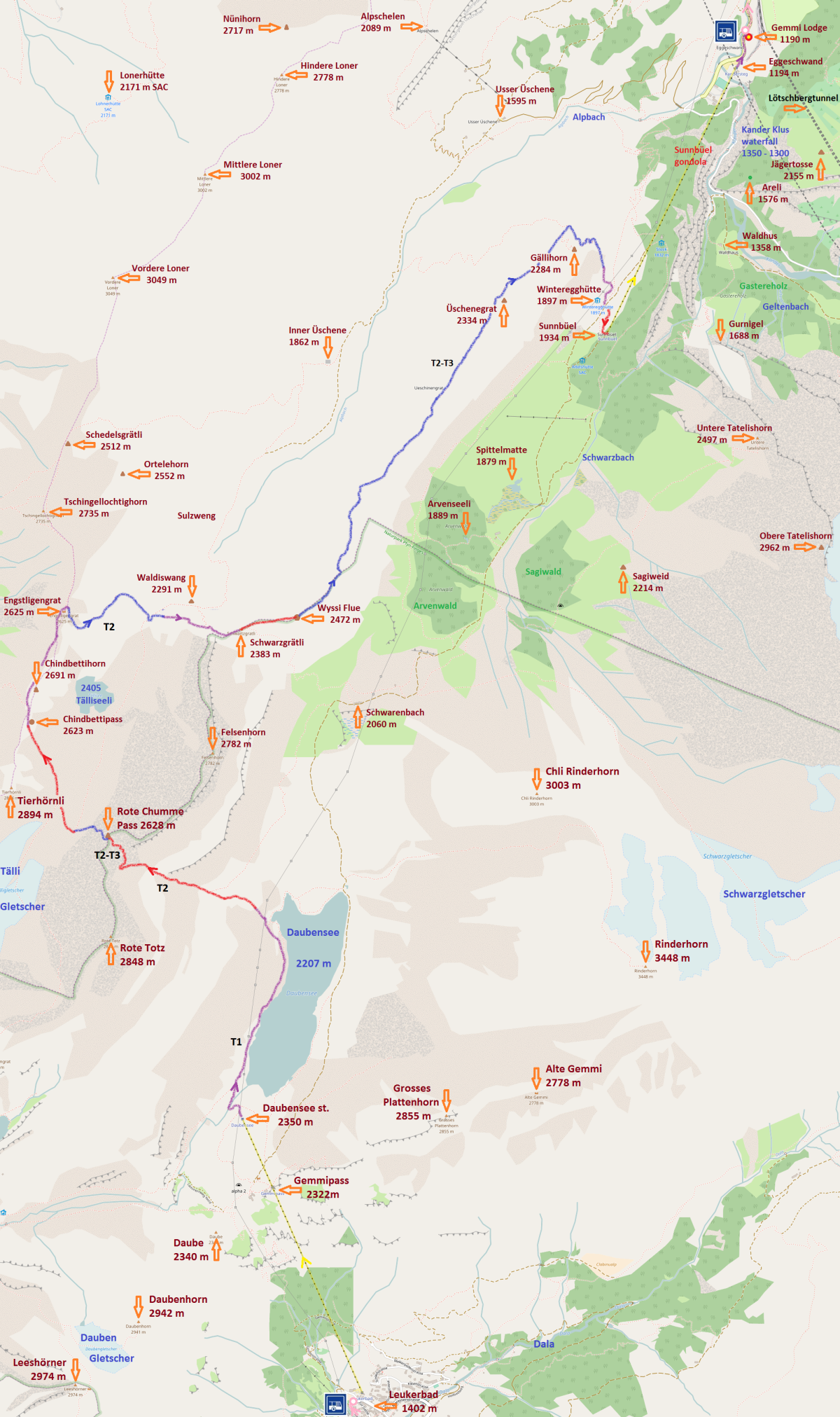
| 10 | Ut1 - Üschenental L1 | Usser Üschene - Inner Üschene - Tälliseeli - /Schwarzgrätli - Schwarenbach - Sunnbüel/ | Ut1 |
| 11 | Yd1 - Yoga Entschligental L1 | Golitschenalp - Golitschepass - Elsighorn - Elsigenalp - Panoramaweg - Rybrügg / Frutigen | Yd1 |
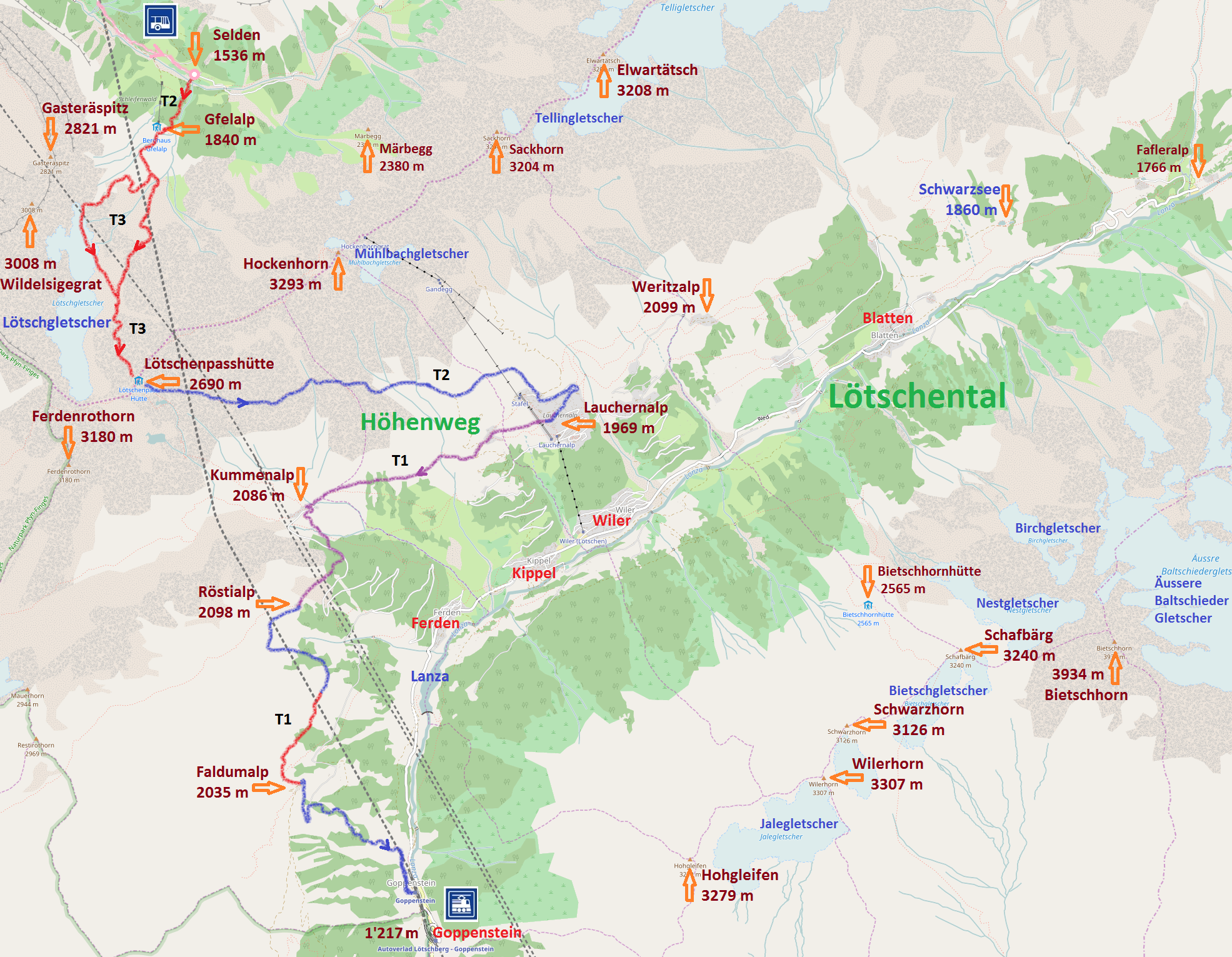
| 12 | Lt1 - Lötschental L1 | Lötschental Höhenweg - Fafleralp - Schwarzsee - Lauchernalp - Kummenalp - Faldumalp - Goppenstein | Lt1 |
| 13 | Ge1B - Gemmi L1 vB | Gemmibahn - Daubensee - Rote Chumme - Chindbettipass - Schwarzgrätli - Üschenegrat - Sunnbüel | Ge1B |
| 14 | Kg1 - Kandergrund L1 | Kander river - Blausee - Mitholz bus | Kg1 |
| 1 | Ks2 - Kandersteg L2 | Usser Üschene - Ryharts - Pathfinder = Kandersteg International Scout Centre - Höh - Muggeseeli | Ks2 |
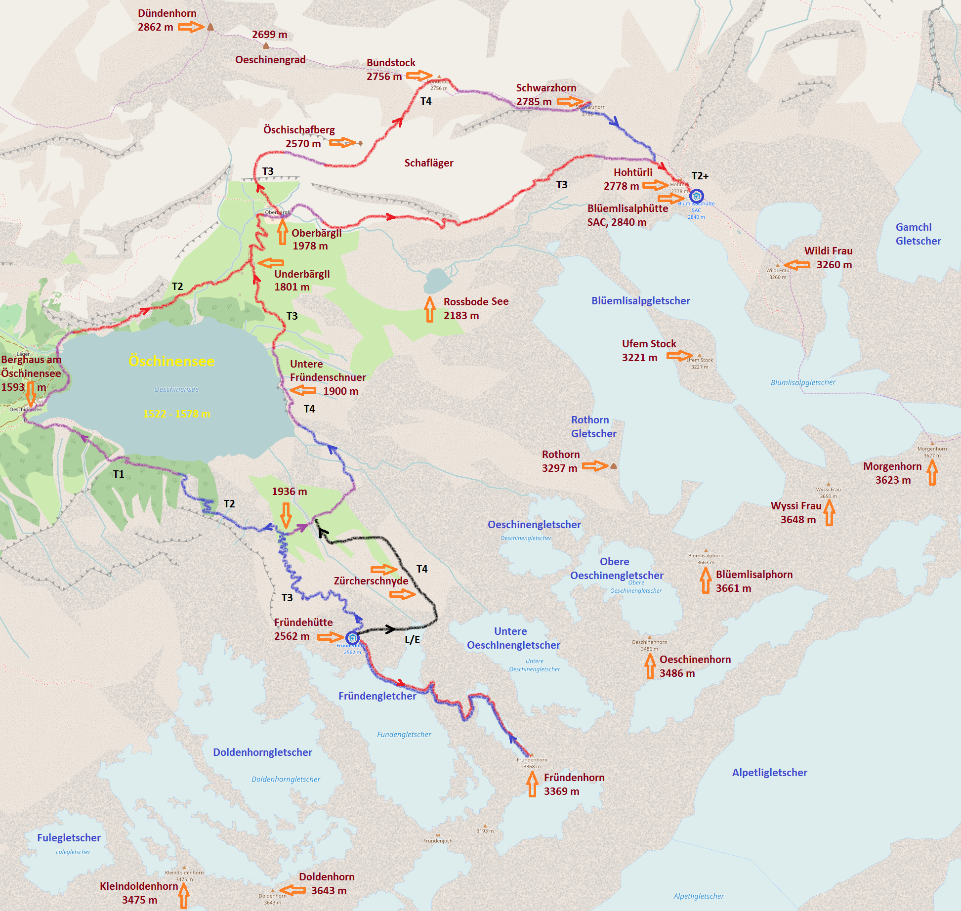
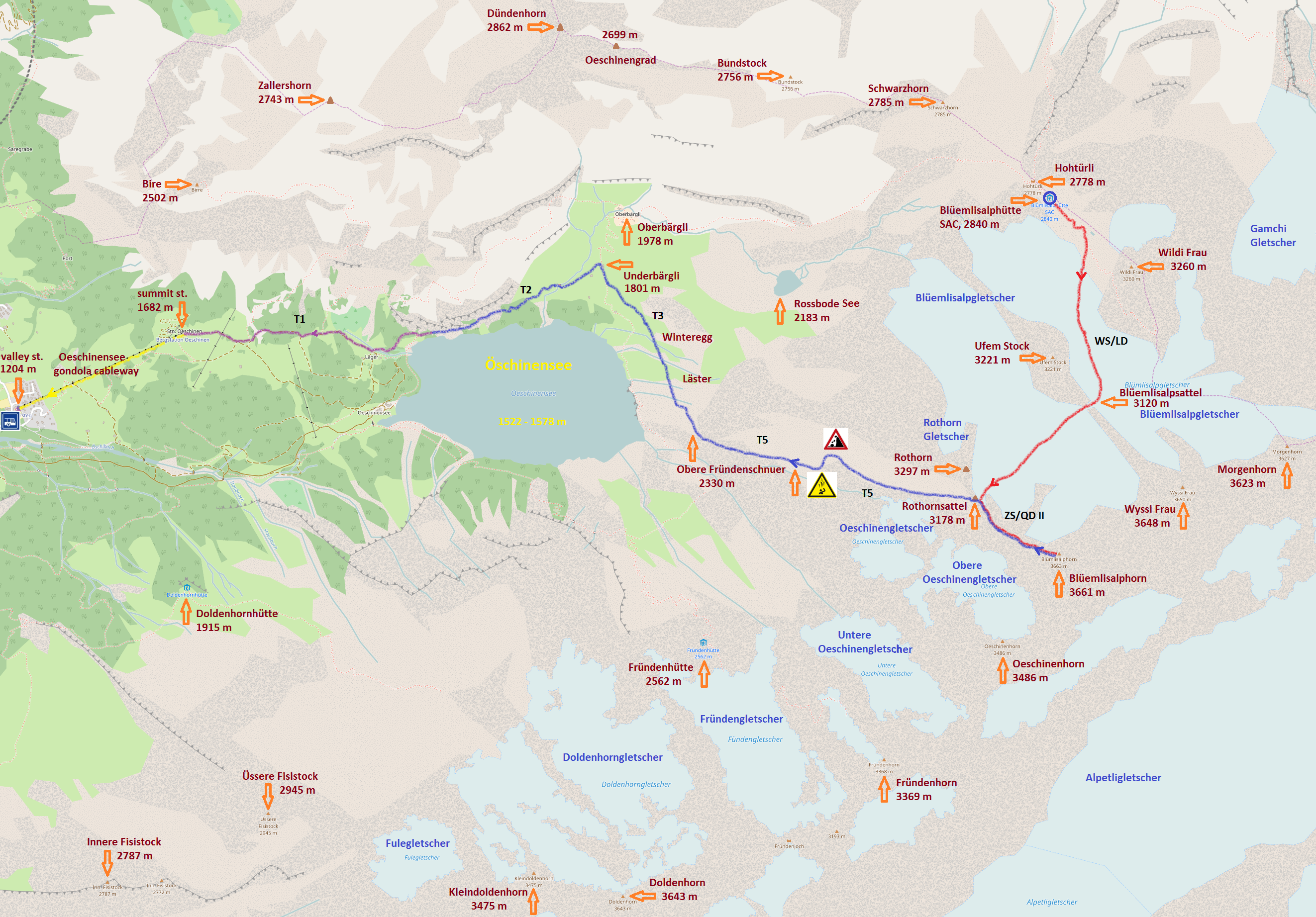
| 2 | Os2A - Öschinensee L2 vA | Öschinensee - Fründenhütte - Fründenschnuer - Underbärgli - Oberbärgli - Rossbode - Heuberg - Biberg | Os2A |
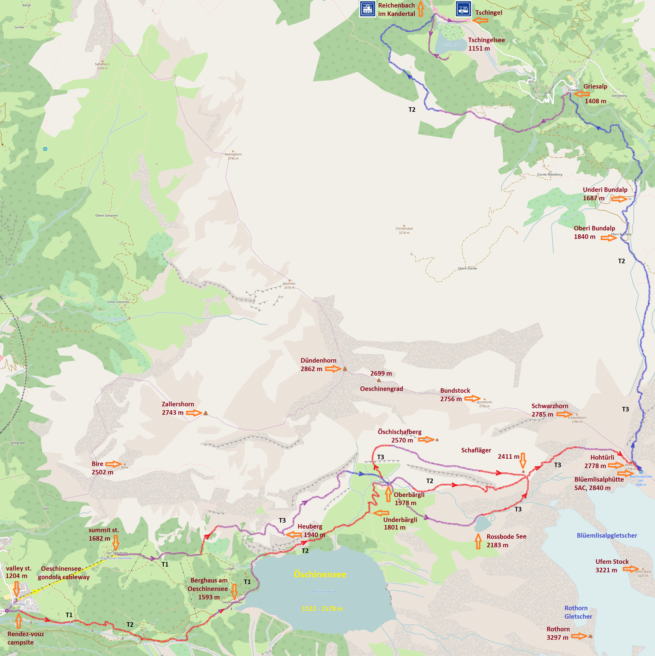
| 3 | Kt2 - Kiental L2 | Öschinensee - Hohtürli - Blüemlisalphütte - Kiental - Reichenbach im Kandertal | Kt2 |
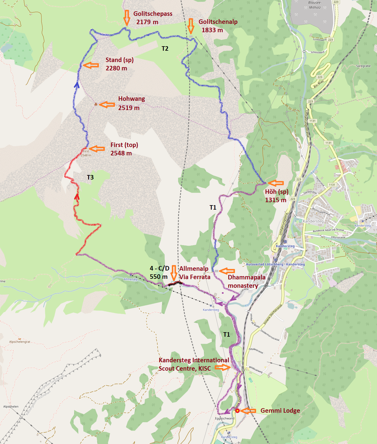
| 4 | Ap2A - Allmenalp L2 vA | Höh - Golitschenalp - Golitschenpass - First - Undere Allme - Allmenalp cable car | Ap2A |
| 5 | Gt2A - Gasterntal L2 vA | Kander Klus - Gasterntal - Waldhus - Selden - Heimritz - Kanderfirn - Mutthornhütte - Selden bus | Gt2A |
| 6 | Ge2A - Gemmi L2 vA | Sunnbüel - Spittelmatte - Sagiwald - Untere Tatelishorn - Obere Tatelishorn - Arveseeli - Winteregghütte - Gällihorn | Ge2A |
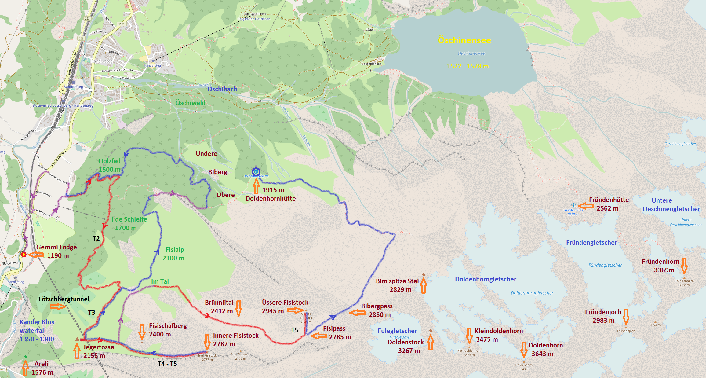
| 7 | Os2B - Öschinensee L2 vB | Holzfad - I de Schleife - Jägertosse - Fisialp - Doldenhornhütte - /Bim spitze Stei - Fründenhütte/ | Os2B |
| 8 | Ap2B - Allmenalp L2 vB | Ryharts / Allmenalp via ferrata - Obere Allme - Bunderspitz - Entschligental - /Adelboden/ - Bus | Ap2B |
| 9 | Gt2B - Gasterntal L2 vB | Waldhus - Gasterespitz - Balmhornhütte - Waldhus - Gurnigel - Sunnbüel - Eggeschwand | Gt2B |
| 10 | Ut2 - Üschenental L2 | Inner Üschene - Schädelsgrätli - Engstligengrat - Tälliseeli - /Schwarzgrätli - Wyssi Flue - Sunnbüel/ | Ut2 |
| 11 | Yd2 - Yoga Öschischafberg L2 | Öschischafberg - Bire / Drei Eidgenossen - Zahlershorn / Öschischafbergwägli - Oberbärgli | Yd2 |
| 12 | Lt2 - Lötschental L2 | Gasterntal - Selden - Gfelalp - Lötschenpass - Lauchernalp - Kummenalp - Faldumalp - Goppenstein | Lt2 |
| 13 | Ge2B - Gemmi L2 vB | Gemmibahn - Rote Chumme - Rote Totz - Tierhörnli - Chindbettihorn - Waldiswang - Üschinental | Ge2B |
| 14 | Kg2 - Kandergrund L2 | Port - Undere Giesene - Blausee - Mitholz bus | Kg2 |
| 1 | Ks3 - Kandersteg L3 | Allmenalp via ferrata - First - Golitschepass - Golitschenalp - Höh - Dhammapala monastery | Ks3 |
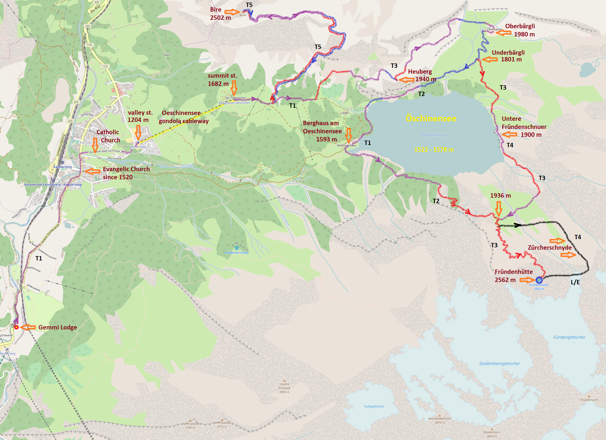
| 2 | Os3A - Öschinensee L3 vA | Öschinensee - Bire - Heuberg - Oberbärgli - Underbärgli - Berghaus - Fründenhütte - overnight | Os3A |
| 3 | Fh3 - Fründenhorn L3 | Fründenhorn - Untere Fründenschnuer - Underbärgli - Hohtürli - Blüemlisalphütte - overnight | Fh3 |
| 4 | Ba3 - Blüemlisalphorn L3 | Blüemlisalphorn - Rothornsattel - Obere Fründenschnuer - Underbärgli - Öschinensee gondola | Ba3 |
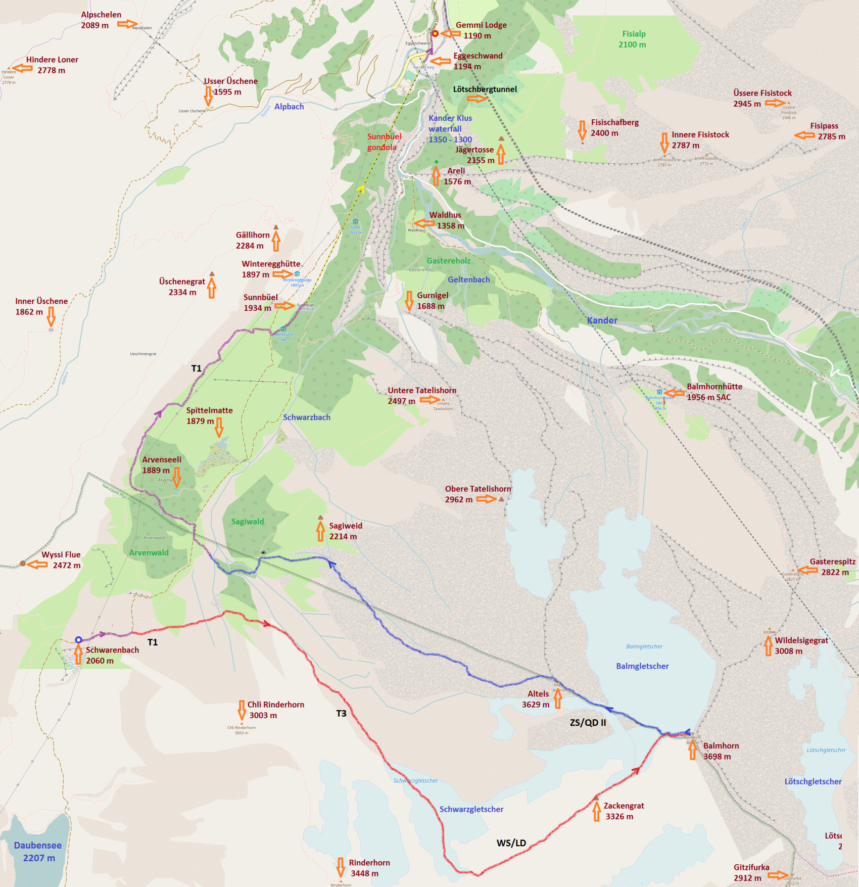
| 5 | Gt3A - Gasterntal L3 vA | Gällihorn - Gurnigel - Waldhus - Gfellalp - Selden - Kanderfirn - Mutthornhütte - overnight | Gt3A |
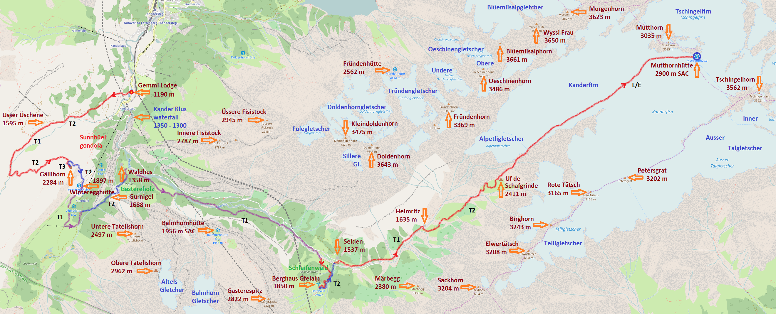
| 6 | Kf3 - Kanderfirn L3 | Kanderfirn - Petersgrat - Tschingelhorn - Mutthornhütte - Mutthorn - Kanderfirn - Uf em Schafgrinde - Heimritz - Selden | Kf3 |
| 7 | Os3B - Öschinensee L3 vB | Holzfad - I de Schleife - Jägertosse - Innere Fisistock - /Üssere Fisistock - Doldenhornhütte - overnight/ | Os3B |
| 8 | Dh3 - Doldenhorn L3 | Doldenhornhütte - Ufem obere Stei - Doldenhorn - Bim spitze Stei - Fründenhütte - Öschiwald | Dh3 |
| 9 | Gt3B - Gasterntal L3 vB | Waldhus - Gasterespitz - Wildelsigengrat - Balmhornhütte - Gfelalp - Lötschenpasshütte - overnight | Gt3B |
| 10 | Hh3 - Hockenhorn L3 | Hockenhorn - Lötschenpasshütte - Lötschental - /Fitzifurka - Gemmipass - Lämmerenhütte - overnight/ | Hh3 |
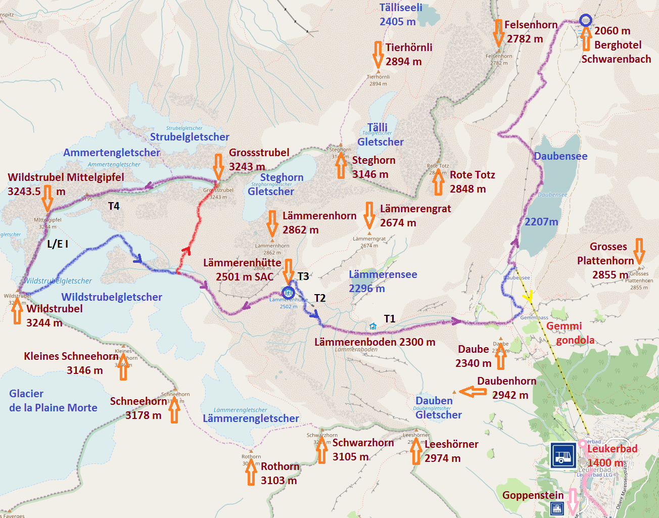
| 11 | Yd3 Yoga Wildstrubel L3 | Grossstrubel - Mittelgipfel - Wildstrubel - Lämmerenhütte - Leukerbad / Schwarenbach - overnight | Yd3 |
| 12 | Ge3A - Gemmi L3 vA | Zackengrat - Balmhorn - Altels - Sagiwald - Spittelmatte - Sunnbüel - Eggeschwand | Ge3A |
| 13 | Ge3B - Gemmi L3 vB | Gemmibahn - Rote Chumme - Tschingellochtighorn - Vordere Lohner - Waldiswang - Üschinental | Ge3B |
| 14 | Kg3 - Kandergrund L3 | Ryharts / ferrata - Allmenalp - Blausee - Mitholz bus | Kg3 |
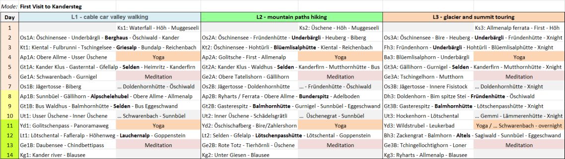
SwissHike Itinerary Gallery, levels L1-valley, L2-mountain, L3-summit for STANDARD PACKAGES: 7 days, 10 days, 14 days - MODE: First Visit


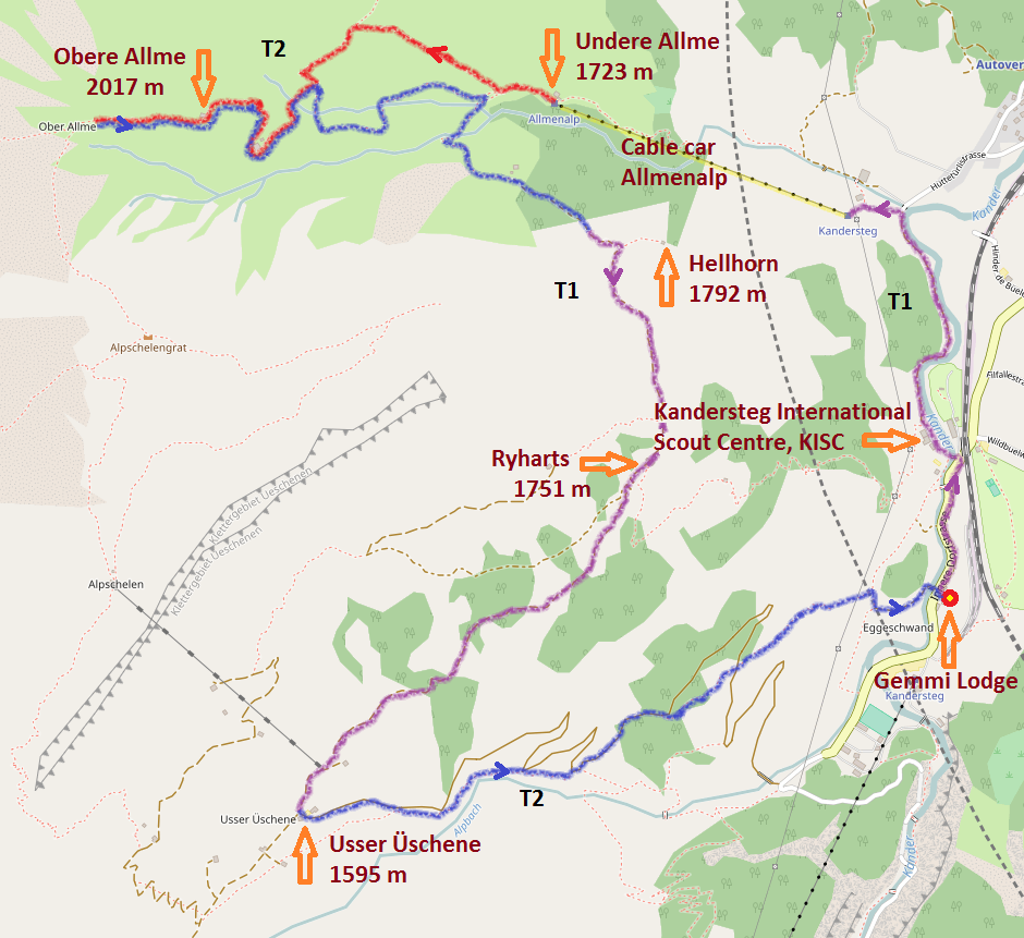


T1 – Valley Hikes
Paths are well cleared. In case they are marked according to SAW standards: marking is yellow. Flat or slightly sloped, no danger of falling. Requirements: None, tennis shoes are fine. No problem to get oriented, even without a map.
Tour examples: Kandersteg – Oeschinensee, Höh Panorama Weg, Vermigel Hut, Männlichen – Kleine Scheidegg, Hut path to Jura Hut.
T2 – Mountain Hikes
Paths with continuous marked-out route. In case it is marked according to SAW standards: white-red-white. Sometimes steep, danger of falling possible. Requirements: Sure footedness sometimes needed. Trekking shoes are recommended. Basic orientation skills.
Tour examples: Heuberg, Wildhorn Hut, Bergsee Hut, Täsch Hut from Täschalp.
T3 – Challenging Mountain Hikes
Paths are not always visible. Exposed sections can be safeguarded with ropes or chains. The hands might be needed for balance. In case the path is marked: white-red-white. Can have exposed sections with danger of falling, scree slopes, pathless craggy ground. Requirements: sure footedness, good trekking shoes. Average orientation skills. Basic alpine experience required.
Tour examples: Fründen Hut, Hohtürli, Sefinenfurgge, Grosser Mythen.
T4 – Alpine Hikes
Path traces are not always present. Some sections require the use of hands. In case paths are marked: white-blue-white. Grounds are relatively exposed, tricky grass slopes, craggy ground, simple firn fields and snow free glacier sections. Requirements: Stable trekking shoes. Basic ability to judge grounds and good orientation skills. Alpine experience required. A sudden change in the weather can make a retreat/fallback difficult.
Tour examples: Bundstock, Forno Hut, Schreckhorn Hut, Mischabel Hut.
T5 – Challenging Alpine Hikes
Often without paths. Some easy climbing sections. In case it is marked: white-blue-white. Exposed, demanding grounds, steep craggy ground. Danger of slipping on glaciers and firn fields. Requirements: Climbing boots. Experienced to judge grounds and very good orientation skills. Good alpine experience also in high alpine areas. Basic knowledge in the use of pick and rope.
Tour examples: Bire, Cabane Dent Blanche, Büttlasse, Salbitbiwak, Bristen.
T6 – Difficult Alpine Hikes
Mostly without path. Climbing sections up to II. Paths are not marked most of the time. Often very exposed. Tricky craggy ground. Glaciers with increased danger of slipping. Requirements: Excellent orientation skills. Advanced alpine experience and well acquainted with the use of technical alpine appliances.
Tour examples: Gross Loner, Niesen ridge, Glärnisch Guppen ridge.
L (E - Easy)
Rock: easy hiking grounds (scree, easy block ridge)
UIAA rating: from I
Firn and Glacier: easy firn slopes, hardly any crevasses
Tour examples: Kanderfirn - Mutthornhütte, Wildhorn normal route
WS (LD - Little Difficult)
Rock: mostly hiking grounds, advanced surefootedness needed, climbing sections are easy and without problems
UIAA rating: from II
Firn and Glacier: usually only a few steep slopes, short steeper sections, only a few crevasses
Tour examples: Balmhorn normal route
ZS (QD - Quite Difficult)
Rock: Repeated belay necessary, quite long and exposed climbing sections
UIAA rating: from III
Firn and Glacier: slopes quite steep, sometimes belay station necessary, a lot of crevasses, little bergschrund
Tour examples: Blüemlisalphorn, Diamantstock East Ridge
S (D - Difficult)
Rock: good sense for the route and efficient handling of the rope needed, long climbing sections, belay stations needed most of the time
UIAA rating: from IV
Firn and Glacier: very steep slopes, belay stations needed most of the time, a lot of crevasses, big bergschrund
Tour examples: Fründenhorn West Ridge, Eiger Middle-Egi Ridge
SS (VD - Very Difficult)
Rock: in difficult sections belay always needed, continuous challenging climbing
UIAA rating: from V
Firn and Glacier: continuous steep grounds, belay station always needed
Tour examples: Doldenhorn East Ridge
AS (ED - Exceptionally Difficult)
Rock: wall sections which require a lot of dedication
UIAA rating: from VI
Firn and Glacier: very steep and vertical sections, require ice climbing
Tour examples: Eiger North Face
EX (XD - Extremely Difficult)
Rock: extremely steep, sometimes overhanging wall sections
UIAA rating: VII and more
Firn and Glacier: most extreme ice climbing
Tour examples: Doldenhorn - Doldorphin, Eiger Czech route